Welcome to the Ethnicity Maps of Southeastern Europe (1930-1941) project website.
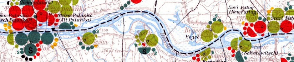
This website is a guide for researchers and educators about the Volkstumskarte series of maps of Romania, Hungary, Slovakia and Yugoslavia. The Volkstumkarte maps are ethnicity maps created by Wilfried Krallert and the Publikationsstelle Wien (P-Stelle) in 1941, in Vienna, Austria. The maps visualize ethnic data from the 1930/1931 Censuses of Romania, Yugoslavia, Slovakia, and Hungary. During the Nazi regime in Austria, the P-Stelle, was a research institute that collected, translated, and analyzed census and government information from countries in South-Eastern Europe.
On this website you will find:
- Access to the maps of Slovakia, Hungary,Yugoslavia and Romania in Google Earth format.
- Information about the print copies at University of Alberta and McGill University
- Translations and interpretations of the map legends in English
- Biographical Information about Wilfried Krallert (a historian, geographer, cartographer, and high ranking official in the SS)
- How cite and credit the maps for research and teaching
- How to obtain scanned copies of these maps
If you have any questions or comments, please contact Rosa Orlandini (project researcher), Map and GIS Librarian, York University Libraries, rorlan at yorku.ca.
Last edited by Rosa Orlandini on November 21, 2013